

- Henri could make landfall like a hurricane on Sunday between Long Island and Cape Cod.
- The storm surge, up to 5 feet in some areas, could be one of the storm’s biggest threats.
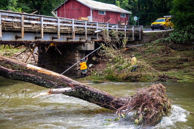
- In North Carolina, 20 people were still missing due to flooding from Tropical Storm Fred.
NEW YORK – Tropical Storm Henri, which is expected to become a hurricane by Saturday, had its sights set on the northeast as the storm’s track continually moved closer to land.
Threatening to bring destructive winds, up to 8 inches of rain and up to 5 feet of storm surge, Henry could be the first major hurricane to make landfall in New England in years.
The storm sparked memories of Hurricane Bob, which made landfall 30 years ago on Cape Cod, cutting off power and running water for days. Bob was the last hurricane to hit Cape Cod and the Islands.
The landing could take place between Long Island and Cape Cod on Sunday, said Da’Vel Johnson, a meteorologist with the National Weather Service in New York City.
The impacts of each storm are slightly different, and with Henry, the storm surge could be a significant threat, Johnson said.
“On Sunday the waves and swell off the water will start to rise,” he said.
Meanwhile, around 20 people were still missing in western North Carolina after severe flooding from Tropical Storm Fred that flooded the state earlier this week. Governor Roy Cooper assessed the damage on Thursday, where some 200 water rescues took place along the still swollen Pigeon River.
And in the Gulf, Grace regained the force of the hurricane on Friday before it crashed into central Mexico for its second landing in the country.
Henri calls Bob back to Cape Cod as parts of New York see first Hurricane watches in 10 years
A combination of storm surges, destructive winds and heavy rain could cause severe damage northeast of Henry.
The storm surge could reach 3 to 5 feet from Watch Hill, Rhode Island, to Sagamore Beach, Massachusetts. The surge along Long Island and all the way to Rhode Island could reach 2 to 4 feet, while the Jersey coast could see 1 to 3 feet of surge, the National Hurricane Center said.
Henri’s winds can arrive from late Saturday to Sunday. Winds were reaching 65 mph as it circled about 800 miles southwest of Nantucket, Massachusetts on Friday morning.
Rainfall of 2 to 5 inches was expected in southern New England, with a few isolated patches of up to 8 inches, possibly causing flash floods.
When Bob landed on August 19, 1991, much of the Cape and the Massachusetts Islands were devastated for days.
Cape Cod is now better prepared than for Hurricane Bob.What if the storm was worse?
“We shut down the whole system in response to Bob 30 years ago, but we wouldn’t have to do it today,” said William Hinkle, spokesperson for utility company Eversource.
Meanwhile, the National Weather Service’s office in New York issued its first hurricane watches for part of its area in 10 years, when Hurricane Irene threatened the area in late August 2011. Sandy in 2012, although ‘officially not a hurricane on landing, also caused a lot of devastation in the region.
Much of eastern Long Island and the Connecticut and Rhode Island coasts were under hurricane watch, while the coast closer to New York was under tropical storm watch.
“Everyone along the Long Island and New York City area has to watch,” Johnson said.
At least 20 people remain missing in North Carolina because of the Fred flooding
Devastating flooding from Tropical Storm Fred was still causing problems in western North Carolina near Asheville, where at least two people were killed and 20 more still missing within days of the storm.
Cooper traveled to Canton in the hardest-hit areas of the state on Thursday, suffering flooding that washed away homes like unmoored boats and drowned residents caught in rapidly rising waters as they rolled down the beds of mountain streams.
“We know that search and rescue efforts don’t stop until we know where people are or where we can’t find someone,” Cooper said as the rescue missions , with the help of the Air National Guard, continued.
About 10 to 15 bridges were damaged, officials said, making it harder to reach people.
Water levels have reached the point of a 100-year flood, an event that has a 1% chance of occurring each year. This damaged the Canton water treatment plant and cut the power to 50,000 customers.
Cooper said the number of people without power had fallen to 1,672 and that there was hope to get the water plant back up and running by the weekend.
He declared a state of emergency as well as an executive decree that relaxed the rules for first responders and farmers having to save existing crops.
Through hitting Mexico again
Hurricane Grace was about 185 miles east-northeast of Veracruz early Friday as the storm is expected to hit Mexico for a second time.
Grace made landfall in the Yucatan Peninsula on Thursday, blocking many streets with fallen branches and trees that destroyed power lines.
Most of the businesses remained closed, but the few that opened saw long lines of people waiting to buy tortillas and other food.
Quintana Roo Governor Carlos Joaquín said the storm cut power to some 84,000 customers in Cancun and 65,000 in Playa del Carmen, Cozumel, Puerto Aventura and Tulum. But he said no deaths had been reported.
A lane of the highway between Playa del Carmen and Tulum was blocked by a fallen road sign. A gas station was destroyed when a large pavilion exploded, smashing two cars.
Winds from Friday’s storm had returned to 85 mph and were heading west at 15 mph.
Contributors: Doug Fraser and Cynthia McCormick, Cape Cod Times; Joel Burgess, Asheville Citizen Times; The Associated Press